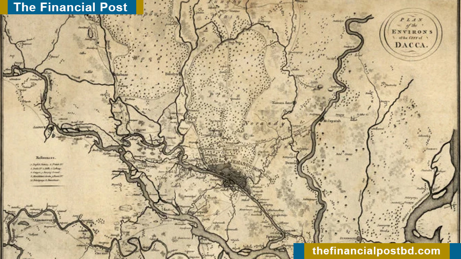
Among European settlers, the Portuguese were the first to arrive in eastern Bengal (in present-day Chattogram, Bangladesh) in 1537AD. Subsequently, other Europeans, such as the Dutch, British, French, Armenians, and Greeks, came to eastern Bengal for trade and commerce. For their convenience in navigation and business activities, they prepared several maps of East Bengal. However, those maps were not drawn to scale, so distances could not be accurately measured. The map only provided general information about place names and locations. After the East India Company took control of the region in 1757 AD, it recognized the need for a comprehensive map of Bengal, including Dhaka, for its own needs. For this reason, in 1776 AD, British cartographer James Rennell prepared a precise and detailed map of Bengal.
To achieve this, Rennell was arrived in Bengal and appointed as a Major in early 1764 AD. He later became Surveyor General of the East India Company. Rennell spent 12 years in Bengal and produced the first detailed map of the region in 1776 AD. His work required extensive travel across Bengal under extremely challenging conditions. He endured malaria, extreme heat and cold, and constant threats from crocodiles, snakes, and tigers. Despite these hardships, he successfully completed the mapping with remarkable dedication and perseverance.
At that time, modern surveying instruments had not yet been widely developed. Rennell used a traditional compass, chain, and Hadley’s Quadrant to record longitude and latitude. He first prepared small regional maps, which he compiled after returning home. In 1780 AD, he published the Bengal Atlas and a memoir. Though titled Bengal Atlas, it covered Bengal, Bihar, Odisha, and much of northern India. Rennell’s map was the most reliable reference until modern cartography.
In his map, Dhaka was labeled as Jehanguirnagur, Tejgaon as Tizgong, the Buriganga River as Boorygonga, and the Arial Khan River as Arika. Initially, these maps were published in segments for the East India Company’s use. Later, Rennell commercially published a comprehensive map and memoir for foreign travelers intending to visit India. At that time, it was the only dependable map of Bengal. Subsequently, more maps of Dhaka were prepared during the British period (1859, 1905, and 1924 AD) the Pakistan period (1966 AD), and in Bangladesh using modern technology.
According to Rennell’s map published in 1780 AD, Dhaka was once interwoven with major rivers such as the Buriganga, Shitalakshya, Dhaleshwari, Bangshi, Balu, and Turag, as well as numerous canals forming a network across the city. These water bodies were integral to the natural hydrological system and closely connected to the city’s geomorphology. They served as primary routes for transportation, trade, and drainage of rainwater, playing a vital role in controlling waterlogging and maintaining environmental balance.
Unplanned urbanization, infrastructure growth, illegal encroachment, land filling, and weak management led to the loss of many canals. Consequently, waterlogging, pollution, and decreased water retention have worsened.
BNP’s 2026 Election Manifesto proposes excavating and restoring 20,000 kilometers of rivers and canals. The Urban Development Directorate (UDD) has started integrated research to assess the location, current condition, and functionality of lost and existing rivers, canals in Dhaka.
Through this research, it will be possible to identify the causes of failure in the natural drainage system, locate waterlogging-prone areas, and develop climate-sensitive spatial planning. It will also provide timely, data-driven guidance for policymaking in water management, including the development of a National Water Grid Management system.
Md. Mahmud Ali
Director (Additional Secretary)
Department of Urban Development
FP/MI